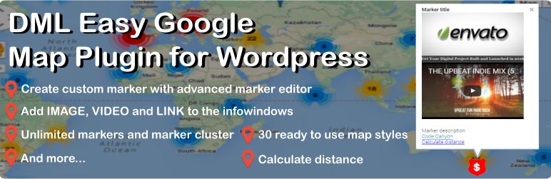
Ready to use 30 map styles including Roadmap, Sattelite and Terrain, Scroll wheel lock, Adjustable map height, Adjustable map zoom level, Developed with technology, Including source-code, Easy to use and maintain., More features coming soon...
Easy to use DRAWING TOOL, Supports adding multiple polygons, Customize the color of the polygon, Customize the color of the polygon, Add custom description for each polygon.
Add real-time information as layer with one click, Add public transit network of city as layer with one click, Add bicycle information as layer of bike paths, suggested bike routes and other overlays specific to bicycling with one click.
Editing shape of the polygon by dragging, Mouseover color changing, Add image to the info window of each polygon, Add YouTube to the info window of each polygon, Add link to the info window of each polygon.
Editing radius of the circle by dragging, Changing the location of the circle by dragging, Mouseover color changing, Add image to the info window of each circle, Add YouTube to the info window of each circle, Add link to the info window of each circle.
Add image, YouTube video and link to infoWindow of the Shapes ..
Upload the plugin files to the wp-content plugins directory, or install the plugin through WordPress plugins screen directly..
Then it's possible to customize map, pin new location and edit the location description.. Since this plugin uses GOOGLE MAP service and As of June 22, 2016 Google no longer supports usage of Google Map, user has to take API key..
Browse the code, check out SVN repository, or subscribe to the development log by RSS...
Updated To prevent creating new marker on each click on the map, from now on Anonymous users have to right-click on the map to Calculate Distance, Fixed minor bug reasoned awkward alert DEBUG mode, 1.6.0.
Read more
Related items: